Space Shepherd. Using space systems to save human lives
2014
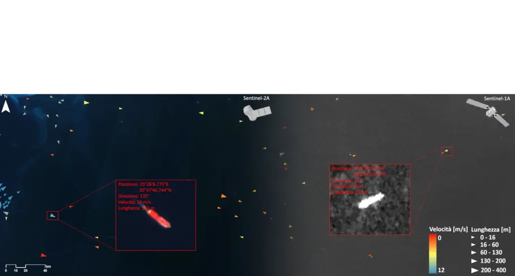
The Mediterranean has always been considered an area of intense political, economic and cultural exchanges, but over the last decade it has also become a stage for intense migratory flow towards Europe. Following an exponential increase in the number of arrivals by sea, European institutions are searching for new solutions to reinforce the monitoring of the external borders of the European Union. However, this operation, which involves a vast geographic area, is complex and costly if performed exclusively using traditional means (ground radar, aircraft and sea vessels). Against this backdrop, the Space Shepherd research project has been responsible for a feasibility study of an integrated optical and radar system for the identification, monitoring and tracking of unknown vessels travelling in the Mediterranean Sea using data from optical and radar sensors hosted on satellites that are already operational. Beginning with a study of the migration phenomenon in the Mediterranean and analysis of the state-of-the-art ship detection ship detection techniques using ground observation data, a more efficient algorithm was developed to identify even very small vessels (10m), carefully combining high and medium resolution spatial optical and radar data. This data, which was acquired on different dates and in different areas, was processed using a broadly parallel procedure, which made it possible to identify the vessels using an automatic algorithm based on an object-based approach. A subsequent spatial analysis made it possible to estimate the position, direction, length and speed of the vessels identified.
The integration of the results with real data provided by the Automatic Identification System (AIS) made it possible to validate the automatic estimates of length and direction and to distinguish between legal vessels and those of migrants.